The Etihad Rail project is the UAE’s first nationwide rail network, spanning roughly 900 km from the Saudi border in Al Sila (Ghuwaifat) to Fujairah on the east coast. Upon completion, this single integrated system will link all seven emirates and 11 major cities and regions through strategically placed stations. Designed to reshape travel across the country, the rail network will connect major urban centers, industrial hubs, and even remote desert towns—providing fast, safe transport while easing road congestion. In late 2025 and early 2026 Etihad Rail revealed the full passenger network: first announcing stations in Abu Dhabi, Dubai, Sharjah, and Fujairah, and then adding seven more stops (Al Sila, Al Dhannah, Al Mirfa, Madinat Zayed, Mezairaa, Al Faya, and Al Dhaid).
Overview of the Etihad Rail Network
- Network length: ~900 km from Al Sila (UAE-Saudi border) to Fujairah.
- Geographic reach: Connects all 7 emirates. Stations span from Abu Dhabi’s western Al Dhafra region to Fujairah on the Gulf of Oman.
- Integrated system: First fully national passenger rail system in the UAE. Built to international standards and linked to the planned GCC railway.
- Key service: Freight operations began in 2023 (serving ports and industrial zones). Passenger services are slated for 2026, with trains carrying up to 400 people each.
- Speed and capacity: Trains will run up to 200 km/h, allowing Abu Dhabi–Dubai trips in about 57 minutes (versus 90+ min by car) and Abu Dhabi–Fujairah in ~105 minutes.
- Connections: Station locations are chosen to link city centers, airports, ports, industrial parks, and university hubs—enabling seamless travel and integration with existing transport networks.
Primary Passenger Route: Abu Dhabi – Dubai – Fujairah
In its first phase, Etihad Rail’s passenger service will connect Abu Dhabi to Dubai and on to Fujairah. The initial route runs from Abu Dhabi’s Mohammed bin Zayed City station to Dubai’s Jumeirah Golf Estates stop, then eastward to Fujairah’s Al Hilal area. This tri-city corridor demonstrates the map’s vision: linking the two largest emirates and extending service to the UAE’s east coast. Gulf News notes that this network will “reshape travel across the UAE, linking major cities, regional hubs and more remote towns through a nationwide passenger rail network ”.
In addition to the main Abu Dhabi–Dubai–Fujairah corridor, every emirate will have at least one station. For example, Sharjah is served at University City, strengthening rail access in the northern emirates, and Abu Dhabi’s wide Al Dhafra region has multiple stops (discussed below). The full map, when complete, ensures no emirate or major population center is left out.
Major Stations on the Map
The Etihad Rail map includes 11 passenger stations. Below are the main stops and the communities they serve:
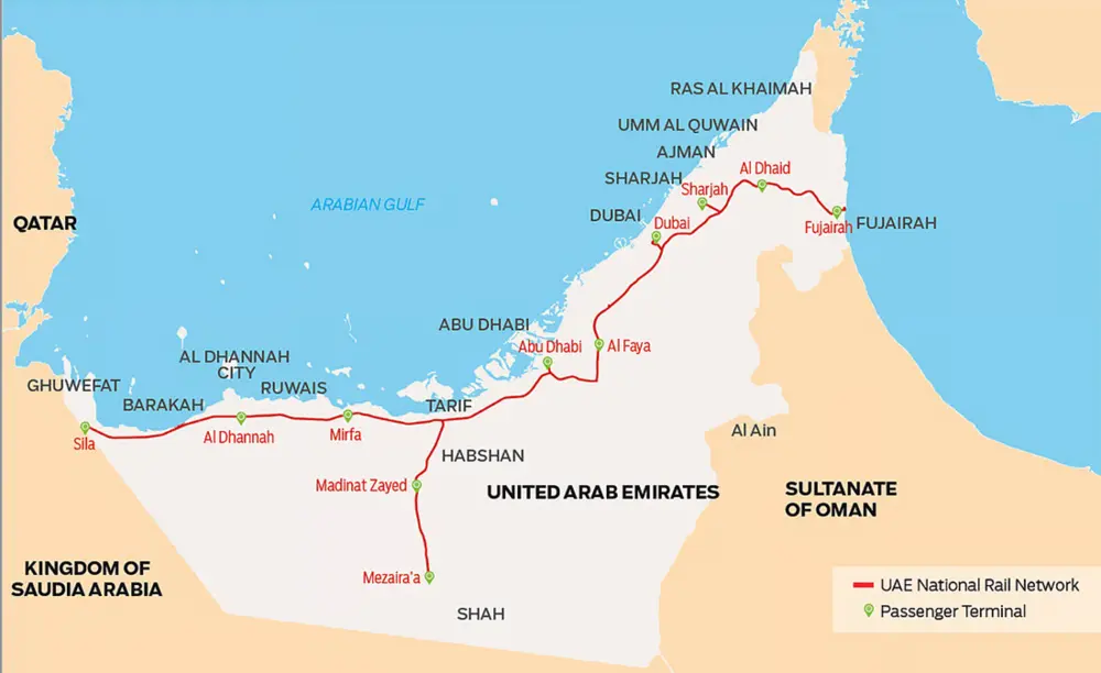
- Mohammed Bin Zayed City (Abu Dhabi): This is the most central station in Abu Dhabi, just ~30 minutes from Zayed International Airport. It serves suburban areas like Mussafah, Shakhbout City, and Bani Yas, acting as a key gateway to the capital’s downtown. The Etihad Rail Abu Dhabi network will tie this station to the rest of the country via Sheikh Khalifa Highway, linking the capital to Dubai and beyond.
- Jumeirah Golf Estates (Dubai): Dubai’s only rail station is at this gated golf community along Sheikh Mohammed bin Zayed Road. It sits adjacent to the Dubai Metro’s Route 2020 extension, providing seamless transfers to Dubai’s urban transit. Nearby communities include Al Furjan, Dubai Investment Park, and Expo City Dubai. This station is also about 30 minutes from Al Maktoum International Airport, aligning rail with Dubai South’s growth plans.
- University City (Sharjah): Located in Sharjah’s education district, this stop serves several university campuses and thousands of students. It’s only 10 minutes from Sharjah International Airport, strengthening the link between higher education and air travel. As a strategic northern hub, it improves connectivity for Sharjah’s inner regions (University City) to the rest of the UAE.
- Al Hilal area (Fujairah): This eastern terminus station sits just outside Fujairah city. It provides a direct rail link to Fujairah and the nearby town of Qidfa on the east coast. Once operational, passengers will be able to travel from Dubai or Abu Dhabi to the Gulf of Oman coast entirely by train.
- Al Sila’ (Abu Dhabi, Al Dhafra): The westernmost station in the network, Al Sila’ lies at the UAE’s border with Saudi Arabia. It serves the small town of Ghuweifat. In the long term this stop is crucial for the planned Gulf Cooperation Council (GCC) railway, which will link the UAE with Saudi Arabia. Even now, Al Sila’ connects remote desert communities of western Abu Dhabi to the national grid.
- Al Dhannah (Abu Dhabi): Formerly known as Ruwais, Al Dhannah is ~240 km west of Abu Dhabi city. It’s a major oil-and-gas hub (home to ADNOC’s Ruwais industrial complex). The rail station here will serve the large, self-contained Ruwais community and its adjacent industrial zones. Bringing rail service to this remote area highlights the map’s goal of linking economic hubs across the emirate.
- Al Mirfa (Abu Dhabi): This coastal town in western Al Dhafra was once a fishing village and is now a growing suburban community. Al Mirfa will get an Etihad Rail stop along the coast road. The station will give residents a rapid connection northward to Abu Dhabi city and beyond and will encourage tourism (Al Mirfa is known for its beach and annual watersports festival).
- Madinat Zayed (Abu Dhabi): The administrative center of Al Dhafra, Madinat Zayed sits roughly 180 km southwest of Abu Dhabi city. It’s surrounded by desert and oil fields and acts as a regional hub. The Etihad Rail line passes just south of town, offering Madinat Zayed’s population direct rail access to the rest of the country. (It also ties into major highways like E45 and E11, further integrating road and rail networks.)
- Mezairaa (Abu Dhabi): A village on the edge of the Liwa Oasis, Mezairaa is known for its historic fort and palm groves. In the rail map, Mezairaa represents the far southwest terminus within the UAE before reaching the Empty Quarter. Rail service here links a traditionally remote desert community and tourism site to the national grid.
- Al Faya (Abu Dhabi–Dubai corridor): This station is in Abu Dhabi emirate but very close to the Dubai border. Al Faya is a key transit point between Abu Dhabi, Al Ain, and Dubai. It already hosts an inland container depot, and with Etihad Rail, it will become a major freight and passenger hub, further supporting the economy between the emirates.
- Al Dhaid (Sharjah): The only station in the interior of Sharjah, Al Dhaid lies about 60 km east of Sharjah city on the desert plain at the base of the Hajar Mountains. It is a historic oasis town known for date palms and agriculture. The Etihad Rail stop here will open up Sharjah’s rural east, giving farmers and residents rail access to major cities. It links the Sharjah interior to the new national network.
Each of these stations is shown on the official Etihad Rail map, confirming that every town and city listed above is connected by the new rail network. Gulf News emphasizes that these strategically chosen locations will enable seamless links to airports, seaports, and existing metro systems.
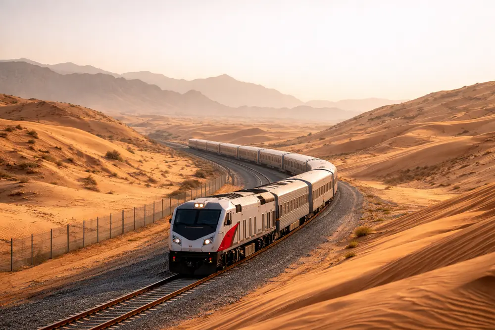
For example, the Etihad Rail alignment even traverses remote desert landscapes in Abu Dhabi. The image above shows a stretch of tracks cutting through golden dunes—evocative of areas like Mezairaa in the Liwa Oasis. This illustrates how the rail map reaches beyond cities into sparse regions, bringing isolated communities onto the national grid. By contrast, other parts of the map thread through dense urban and industrial zones, demonstrating the system’s breadth.
Travel Times and Regional Impact
The new railway will dramatically shorten travel times between emirates. Etihad Rail’s trains, operating up to 200 km/h, will cut commutes: Abu Dhabi–Dubai trips drop to under an hour, and Abu Dhabi–Fujairah journeys fall to roughly 105 minutes. Each modern passenger train holds about 400 people and offers Wi-Fi, power outlets, and spacious seating. Services will run frequently on a precise schedule, providing a reliable alternative to congested highways.
Beyond speed, the social and economic benefits are huge. Officials note that the network will boost tourism by making even remote attractions (like Al Mirfa’s coast or Liwa’s oases) easily accessible by rail. It will also support industries by linking ports and factories; for example, the Ruwais and Al Dhafra oil fields now have a direct rail freight option. By shifting freight and passengers from road to rail, Etihad Rail is expected to reduce traffic and emissions.
Integration and Future Outlook
The Etihad Rail map is a key element of the UAE’s long-term transport vision. It is designed to integrate with other modes: most stations provide easy road access and connections to local transit, while several are near airports. As noted in official releases, the railway also “forms an integral part of the planned Gulf Cooperation Council (GCC) railway network," eventually linking the UAE with Saudi Arabia and other neighbors. Indeed, once GCC links are built, the Al Sila’ station will become a gateway to the entire Arabian Peninsula.
By 2026, the complete Etihad Rail passenger network will be in service, aligning with ambitious national goals. The rollout is happening in phases—with the main lines first—to ensure a smooth launch. When operational, the full map will have realized its promise: a nationwide rail network connecting every major town, city, and region. As Etihad Rail’s leadership notes, this is a “cornerstone” project that will enhance mobility, support economic growth, and make the UAE’s long-term vision of integrated transport a reality.